


OLD LIVESTOCK ENCLOSURE ON HIRTA
Splendidly faraway, Hirta in the St Kilda archipelago off Scotland's west coast, lies 112 miles out in the storm-lashed Atlantic. This treeless island group is the most remote in the British Isles and Scotland's first World Heritage Site. The bleak outpost was home to an isolated community for hundreds of years until 1930 when the government and St Kilda's new owner, the Marquess of Ailsa, decided it was no longer fit for human habitation. There are no shops or accommodation on Hirta, just clouds of seabirds and a primitive form of sheep, the Soay. For lovers of the godforsaken, it doesn't come much better than this.
OLD SEA DEFENCES HUMBERSIDE
Spurn Point, or Spurn Head, sits at the tip of the Holderness Plain, which forms the northern banks of the Humber estuary. It is more than three miles long and only 50 metres wide in places. Owned by the Yorkshire Wildlife Trust, this off-the-beaten-track place is a designated National Nature Reserve. In medieval times, a port called Ravenser Odd stood on the sandbanks at the estuary mouth. It had its own market, annual fair, mayor, customs officers, fishing boats, warehouses, windmills, prison and chapel. Represented in the Model Parliament of 1295, it was lost to the encroachments of the sea in around 1360.
VIEW OF THE HARBOUR ON LUNDY ISLAND
Once a refuge for pirates and political plotters due to its isolation, unspoilt Lundy Island, 12 miles off the North Devon coast, is tiny - only three miles long and half a mile wide. It is car free, has a medieval castle, three lighthouses and sometimes basking sharks appear in surrounding waters. There are black rabbits, seals and puffins aplenty, too: in fact, the island's name is believed to come from the Norse for puffin. In the Celtic world, Lundy Island was known as the island of Annwn, considered a holy and powerful place and gateway to the Other World. It is certainly far enough away to remain a world apart.
Cape Wrath, Scottish highlands
One of the last untouched wilderness areas in Britain, this is the most north-westerly point on the mainland. Its name comes from the Norse for "turning point" because this was a stopping-off place on the Viking sea routes from Scandinavia. Cape Wrath, closer to the Arctic Circle than the south of England, is a swathe of trackless moorland and cliffs carpeted with orchids. This expanse on the world's edge is home to a few deer, sheep and one family, the Ures, who live in the lighthouse's outbuildings and own the Ozone Cafe.
The Lizard
Out-of-the-way and scenically dramatic, the Lizard peninsula is the most southerly part of the British mainland. Almost an island, hemmed on three sides by the sea, it offers dramatic cliff walks and includes Sites of Special Scientific Interest. The area is also home to one of England's rarest breeding birds, the Cornish Chough, a species of crow recognisable by its red beak. The National Coastal Path provides access to hundreds of miles of walks, many of which overlook largely inaccessible beaches. Marconi's historic wireless experiments are celebrated at the Marconi Centre at Poldhu and at the Lizard Wireless Station, restored by the National Trust.
LOCH NEVIS FROM SGURR NA CICHE ON THE EDGE OF THE KNOWDART PENINSULA
The Knoydart peninsula on the west coast of Scotland is one of Britain's great wilderness areas. This adventurer's dream is accessible only by a 15-mile hike across serious walking territory or by boat from Mallaig to Knoydart's capital, the hamlet of Inverie. To the south is Loch Nevis - the "Loch of Heaven" and - to the north Loch Hourn, the "Loch of Hell", while in the midst of the peninsula are four majestic Munros, the name given to Scottish mountains over 3,000ft. The Old Forge, mainland Britain's remotest pub, is in Inverie.
DARTMOOR PONY
Covering an area of 368 square miles, vast tracts of Dartmoor are bleak and wild. Other swathes of the moor have an otherworldly mystique enhanced by the wealth of bronze age features scattered across the land. Known for its unique landscape of dense heaths, blanket bogs and ancient woodland, Dartmoor is the largest and highest upland in southern Britain, exposed to strong winds and high rainfall. The moorland is sprinkled with granite hilltops called tors that provide habitats for wildlife. Tors are also popular nesting sites for birds including peregrine falcons and as many as 60 different species of lichen grow there, some more commonly found in the Arctic. 
HAW FROST & MIST IN THE FOREST OF BOWLAND
Grandeur and seclusion characterise this area of valleys, moors and hills lying mainly in rural Lancashire. The name "forest" is used in its traditional sense of "royal hunting ground" and much of the land still belongs to the British crown as part of the Duchy of Lancaster. In the past wild boar, deer, wolves and wild cats roamed free but nowadays you are more likely to happen upon brown hares and bats or curlews and lapwings. Here in 1640, George Fox, an itinerant shoemaker, had a vision on Pendle Hill, which led to the birth of the Quaker movement.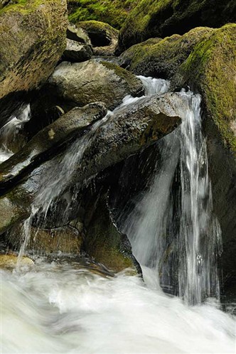
River in spate in the Cambrian mts.
The sparsely populated Cambrian Mountains region straddles the Snowdonia and Brecon Beacons national parks. The area, one of raw natural beauty, has miles of inspiring scenery and is the source of numerous rivers including the Wye and Britain's longest river, the Severn. Sheep graze on the wild, uninhabited uplands while in the valleys, deciduous woodland dating back to the middle ages still exists. Wildlife here include a glorious icon of Wales, the Red Kite, as well as black grouse and otters.
Night landscape over the North Pennines
Rich in wildlife with herb-strewn hay meadows, heather moorland and noted for its rare flora and fauna, the peaceful, unspoiled landscape of the North Pennines is a designated Area of Natural Beauty. This region of epic spaces, with tumbling waterfalls and impressive moorland views, was once an important lead mining centre and traces of abandoned lead mines can still be seen. Local man Isaac Holden, a 19th century lead miner turned Methodist preacher and tea seller, has a 36-mile (58 km) circular walk named after him - Isaac's Tea Trail. It runs from Ninebanks via Allendale, Nenthead and Alston.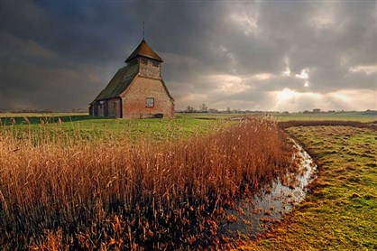
A HISTORIC CHURCH IN A CANAL IN ROMNEY MARSH
Romney Marsh is an area of flat, open, windswept marshland, home to greylag geese, Bewick's swans and lapwings, drawn to Romney's ethereal bleakness. Rather less poetically, it is also home to the blood-sucking medicinal leech. Famed for its emptiness, sweeping skies, sense of solitude and wild plants, its strong feeling of remoteness provided inspiration to creative types like Rudyard Kipling, HG Wells and Joseph Conrad, who either used it as a setting for their novels or worked in the area. Romney Marsh sheep, a hardy breed with hooves resistant to foot rot, graze fields separated by ditches.
BAMBURGH CASTLE
Lonely and wild, this sparsely populated coastal area sweeps along fine beaches, sand dunes and towering cliffs. Ancient black basalt meets the sea in low headlands and rocky coves, providing a dramatic setting for atmospheric Bamburgh Castle, once the royal seat of the kings of Northumbria. The dunes, marshes and mudflats of the Lindisfarne national nature reserve are one of the best sites in Europe for waders and waterfowl. There is no continuous road or footpath running the length of the coast so contributing to and protecting its seclusion.