


Today ushered in two traditions in Oklahoma--one positive and one negative.
First the Good News: Major league baseball officially opened its season today with--guess what--a "Cubbie" loss in extra innings after tying the game in the bottom of the ninth with a three-run homer. They are truly the "hard-luck kids."
I always pull for them because they are the perennial underdogs, and I'm a sucker for an underdog. But, truth be told, I really have been a Yankees fan since I was old enough to watch them play. Back in the 50's the Yankees were the power in the American League while the Brooklyn Dodgers dominated the National League.

These two teams, just across the river from one another, played some classic World Series in those days. Names like Mickey Mantle, Roger Maris, Whitey Ford, Moose Scowran, Phil "The Scooter" Rizzuto, Yogi Berra for the Yanks and Pee Wee Reese and Roy Cambanella for the Dodgers still stick in my memory. I remember exactly their positions, their fielding skills and their respective strengths and weakness at the plate.
As time has gone by, I have become a much bigger football fan and don't follow baseball that closely anymore. But I still have a soft spot in my heart for all those great Yankee/Dodger World Series of the past.
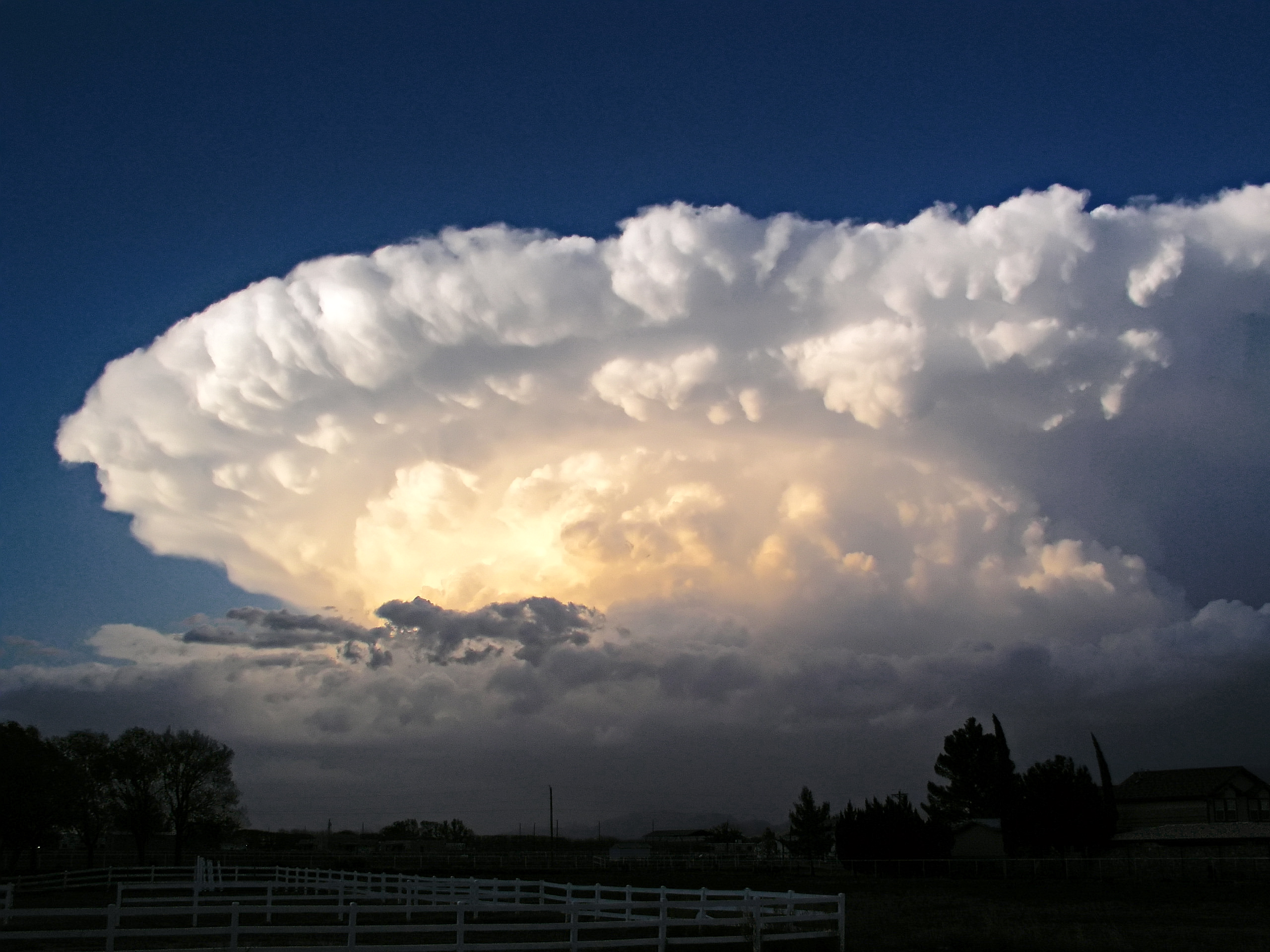
Now the Bad and The Ugly News: Tornado Season officially got underway in Oklahoma early this morning when a twister struck the outskirts of Edmond, an Oklahoma City suburb, taking off roofs , tossing cars, around, downing power lines, and scattering debris.


Tornado Season in Oklahoma runs roughly from March through May. Last evening was our first severe weather night. This was the weakest of tornadoes--an F1--which usually generates a funnel with winds inside its vortex of 80 to 120 miles per hour. As the speed of the wind increases, so does the severity of the storm, up to an F5, the most catastrophic of all twisters.
The chances of a tornado dropping from the sky increase when a mass of cold air collides in the upper atmosphere with a mass of warm air. That sets the stage for a huge super cell, structures, often topping out at 40,000 feet.
A supercell is a severe thunderstorm with a deep, continuously rotating updraft (a mesocyclone).[1] Supercell thunderstorms are the largest, most severe class of thunderstorms.
Supercells can be any size, large or small, low or high topped. They usually produce copious amounts of hail, torrential rainfall, strong winds, and substantial downbursts. Supercells are one of the few types of clouds that typically spawn tornadoes within the mesocyclone, although only 30% or less do so.[2]
Supercells can occur anywhere in the world under the right
pre-existing weather conditions. According to some, the first storm to
be identified as such was the Wokingham storm over England, which was studied by Keith Browning and Frank Ludlam in 1962.[3] As with tornadoes in general, they are most frequent in the Great Plains of the United States.
Features of a supercell


Diagram of supercell from above. RFD: rear flank downdraft, FFD: front flank downdraft, V: V-notch, U: Main Updraft, I: Updraft/Downdraft Interface, H: hook echo
- Overshooting top
This "dome" feature appears above the anvil of the storm. It is a
result of the powerful updraft. If too close it cannot be seen from the
ground.
- Precipitation-free base
This area, typically on the southern side of the storm in North
America, is relatively precipitation free. This is located beneath the
main updraft, and is the main area of inflow. While no precipitation
may be visible to an observer, large hail and rain may be falling from
this area. It is more accurately called the main updraft area.
- Wall cloud
The wall cloud forms near the downdraft/updraft interface. This "interface" is the area between the precipitation area and the precipitation-free base.
Wall clouds form when rain-cooled air from the downdraft is pulled into
the updraft. This wet, cold air quickly saturates as it is lifted by
the updraft, forming a cloud that seems to "descend" from the
precipitation-free base. Wall clouds are common and are not exclusive
to supercells: Only a few actually produce a tornado. Wall clouds that
persist for more than ten minutes, wall clouds that seem to move
violently up or down, and violent movements of cloud fragments (scud or
fractus) near the wall cloud are indications that a tornado could form.
- Mammatus clouds
Mammatus (Mamma, Mammatocumulus) are bulbous or pillow-like cloud formations
extending from beneath the anvil of a thunderstorm. These clouds form
as cold air in the anvil region of a storm sinks into warmer air
beneath it. Mammatus are most apparent when they are lit from one side
or below and are therefore at their most impressive near sunset or
shortly after sunrise when the sun is low in the sky. Mammatus are not
exclusive to supercells and can be associated with developed
thunderstorms and cumulonimbus.
- Precipitation area
This is the area of heaviest precipitation. Between the
precipitation-free base and the precipitation area, a "vaulted" or
"cathedral" feature can be observed. In high precipitation supercells an area of heavy precipitation may occur beneath the main updraft area.
- Flanking line
A line of smaller cumulonimbi or cumulus that form in the warm rising air pulled in by the main updraft.
[edit] Radar features of a supercell

Radar reflectivity map.
- Hook echo or Pendant
The "hook echo" is the area of confluence between the main updraft
and the rear flank downdraft (RFD). This indicates the position of the
mesocyclone, and likely a tornado.
- Bounded weak echo region (or BWER)
This is a region of low radar reflectivity bounded above by an area
of higher radar reflectivity. This is evidence of a strong updraft.
- Inflow notch
A "notch" of weak reflectivity on the inflow side of the cell. This is not a V-Notch.
- V Notch
A "V" shaped notch on the leading edge of the cell, opening away
from the main downdraft. This is an indication of divergent flow around
a powerful updraft.
