


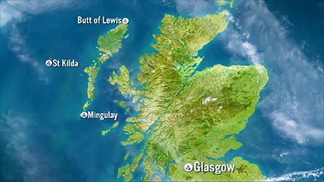
This rugged remote coast is a wonderland of stacks, secret inlets and wind swept secluded beaches. The dramatic coastline is rich with culture and traditions which are deeply rooted across the 120 islands that make up the Outer Hebrides.
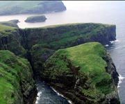
Mingulay is the second most southerly of the group of islands known as the Bishops Isles which are to be found at the Southern tip of the Outer Hebrides.
It takes its name from the Norse for "big island". It measures two-and-a-half miles by one-and-a-half, and has an area of just under 1600 acres. Largely comprising gneiss rocks that have stood here for 3,000 years, they have eroded to form impressive rock stacks and majestic cliffs rising over 150m in height (1 metre = 39” – just over a yard).
It's hard to imagine that anyone could settle here. For 2,000 years a community lived here until 1912 when Mingulay lost its community for good. In the 1880s the island had a thriving community with a population of 160.
The community had an age old lifestyle with work being shared between the men and women. When the men went out fishing the women would tend to the cattle, do the weaving or pluck the sea birds so that feathers could be sent to the neighbouring Island of Barra and onwards to Glasgow.
History and traditions were passed on by word of mouth.
Many people memorised their family line by adding the names of their ancestors to their own full names. It's a tradition that survived the test of time, and one that means Callum can trace his family line back for 500 years!!!
Mingulay has been owned by the National Trust for Scotland since 2000 and two buildings still stand: the Schoolhouse, which was built in the 1880s by the Free Church Ladies' Association and later used as a sheep farmer's bothy and the Chapel House, a Catholic priest's house built in 1898.